Back to all News

New Norwegian smallsat in space

New Norwegian smallsat in space

NorSat-4. Illustration: The Norwegian Defence Research Establishment

Congratulations to Norwegian Space Agency on the successful NorSat-4 launch.

The NorSat-4 satellite has now started its journey in a low orbit around the globe.

“Space Norway is proud to have assisted the Norwegian Space Agency in developing the NorSat-4 satellite, and we are ready to operate it,” says Ivar Spydevold, CEO of Space Norway’s subsidiary Statsat.

The operation centre at Statsat has already made contact with the satellite.

“All telemetry readings are nominal so far. We are looking forward to operating the NorSat-4 satellite on behalf of the Norwegian Space Agency, states Spydevold.

Space Norway’s role in the Norsat-4 project

Space Norway has supported the Norwegian Space Agency with project management capacity throughout the project.

“We have also supported in setting up data chains between the different organizations,” informs Spydevold.

He adds:

“And we were involved as well in preparing the mission control system to handle the satellite and operate it as part of the constellation of AIS satellites owned by the Norwegian Space Agency and the Norwegian Coastal Administration.”

This satellite is the 7th satellite to be operated by Space Norway’s Statsat on behalf of the Norwegian Space Agency.


Three payloads on board

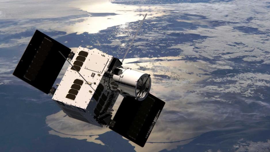
The NorSat-4 carries three payloads, two of which are experimental.

The non-experimental payload is an AIS payload supplying the Norwegian Coastal Administration with additional AIS coverage.

“We hope the AIS payload can start operations as soon as today, Wednesday,” says Spydevold.

The other two payloads are a crypto unit from the Norwegian company EIDEL, and a low light imager (LLI) from the Norwegian Defence Research Establishment. The crypto unit will provide high-level encryption of the mission operation and of the downloaded data.

The LLI is designed to take pictures at very low light, typically periods before sunrise and after sunset. The camera baffle for the LLI is easily identifiable in the picture of the satellite. The baffle ensures that strong light from the sun does not reach the camera, as that would damage or even destroy the imager.

“The satellite manufacturer, UTIAS/SFL, will perform the commissioning, which will take a couple of weeks all in all, then we’ll take over the operation,” says Spydevold.

Facts about NorSat-4

  • Main task: Monitoring ship traffic in Norwegian oceans.
  • Mass: 34 kilograms.
  • Measures: 30 x 31 x 45 cm.
  • Pay load: AIS-receiver (Automatic Identification System), low light camera, and Nanosat encryption device.
  • Owned by the Norwegian Coastal Agency, financed with support from the Ministry of Defence in Norway.
  • Space Norway’s Statsat is operating the satellite.
  • The low light camera is operated by and analysed by Norwegian Defence Research Establishment.
  • Satellite manufacturer is UTIAS / Space Flight Laboratory.
  • Instruments manufactured by Kongsberg Discovery Seatex, Eidel (Eidsvoll Electronics), and Safran Reosc.


Employees at Space Norway Statsat watching the launch online.
Employees at Space Norway watching the Norsat-4 launch online. Photo: Statsat, Space Norway

Back to all News

Abstract from a media interview

Norwegian space industry is the largest in the Nordic

Norwegian space industry is growing. In an interview with the Norwegian online media www.tu.no (Teknisk Ukeblad), Space Norway’s Satcom director, Peter Olsen, stated: “For the first time, the USA has placed a classified payload on a foreign satellite, and the fact that is that this demonstrates the high level of trust Norway enjoys in the industry.

Below you can read an abstract of the article:

Norway has established itself as the largest player in the space industry in the Nordic region, mainly through Space Norway. Space Norway, founded in 1995, has experienced significant growth, and in November 2023, they acquired Telenor Satellite. The company operates several satellites and has plans for more until 2029.

A milestone is that, for the first time, the USA has placed a classified payload on a Norwegian satellite, demonstrating great confidence in Norwegian space expertise. Space Norway’s project “Arctic Satellite Broadband Mission” (ASBM) provides broadband communication in the Arctic regions using HEO satellites.

Traditionally, Norway has relied on other countries for satellite launches, but with the opening of Andøya Space as a spaceport, Norway can now launch satellites into orbit from the European mainland.

Space Norway focuses on various sectors, including satellite communications, Earth observation, and underwater fibre cables. Projects such as MicroSAR and the Svalbard cable are central.

Norway’s unique strengths, especially in the Arctic regions, position the country as an important player in both the European and global space industry. Sustainability and space debris management are critical aspects of their projects. The future looks promising with increased independence and integration with the European space industry.

Back to all News

Important delivery from ASBM

Delivering valuable radiation data to the European Commission

How to efficiently protect satellites from damaging space radiation? Knowing when, where and how much is critical. As of Friday November 29th, Space Norway delivers important space radiation data to the European Commission.

On board Space Norway’s Arctic Satellite Broadband Mission (ASBM) is NORM – a space radiation monitor developed by IDEAS with the support of the European Space Agency and the Norwegian Space Agency.

“Data from this satellite will benefit various EU space programs such as Gallileo, Egnos, SST and Iris2. This partnership has flourished, demonstrating the close cooperation between Norway and the European union in the realm of space. This mission is really a statement to the power of international space cooperation”, says Christoph Kautz, Director for Satellite Navigation and Earth Observation, European Commission.

Since its launch on board ASBM-2 on August 11th, 2024, NORM has been successfully collecting radiation data, including during the important initial phase of orbit-raising. Now, in its nominal orbit, it measures radiation levels all along ASBMs highly elliptical polar orbit and sends it to down to earth.

Gives early warning

NORM has already been able to return valuable insight on the proton flux in orbit, notably during the recent solar storm on October 9th. The instrument observed a very large, rapid spike in proton differential flux over the course of a few days. Data such as this could be useful in providing early warning and assessing risks of ongoing solar activity. Preliminary in-orbit data from the electron channels illustrate the instrument’s ability to precisely characterise the outer radiation belt.

This image has an empty alt attribute; its file name is Bilde1.png

The satellite travels through both the inner and outer Van Allen Belts, enabling cross-calibration with other missions and providing observations of the highly variable particle intensities in these regions.

Representatives from the European Commission, Space Norway, IDEAS and The Norwegian Space Agency gathered in Oslo of Friday for a final review and to celebrate the conclusion of a successful project phase and start of operations.

“I really appreciate the relationships and trust we have been able to build between all parties in the project phase. I am also very happy to see that the service and data that we deliver to the EC is of good quality and in line with what we have worked towards over the last few years. We look forward to the continued cooperation and to deliver valuable data to the EC for many years to come,” says Matias Krogh Boge, SPN Project Director ASBM Radiation Data Service Project.


More information:

The Van Allen radiation belt consists of trapped particles from two belts of radiation that surround the Earth like enormous donuts. It is a zone of energetic charged particles, most of which originate from the solar wind, that are captured by and held around a planet by Earth’s magnetosphere. The magnetosphere traps the high energy radiation particles and shields the Earth from the solar storms and the constantly streaming solar wind that can damage technology as well as people living on Earth. The outer belt is made up of billions of high-energy particles that originate from the Sun and the inner belt results from interactions of cosmic rays with Earth’s atmosphere. The belts endanger satellites, which must have their sensitive components protected with adequate shielding if they spend significant time near that zone.

The European Union develops and operates space infrastructures such as Galileo, EGNOS, Copernicus, Space Surveillance and Tracking and later IRIS2. The NORM data will be useful for design, operations, and diagnosis for these EU missions, and beyond.

In addition, access to the data will be facilitated for the scientific community to contribute to the broader understanding of Sun-Earth interaction and of the effects of space weather on Earth’s magnetosphere, and other space-based technologies, including the derivation of nowcasting/forecasting products and warnings.

In addition, access to the data will be facilitated for the scientific community to contribute to the broader understanding of Sun-Earth interaction and of the effects of space weather on Earth’s magnetosphere, and other space-based technologies, including the derivation of nowcasting/forecasting products and warnings.

NORM‘s particle telescope is a stack of 9 silicon detector diodes and 5 absorbers, designed as an easily adaptable unit for satellite missions in GEO, LEO, and HEO.

The ASBM satellites, composed of 2 satellites placed in highly elliptical TAP orbits with an orbital period of 16 hours and crossing altitudes between 8,700 and 43,000 km provide broadband telecommunication over the Arctic.

Satellite operators are venturing into the Arctic to improve connectivity as the changing atmospheric and geopolitical climate drives demand for more bandwidth in one of Earth’s last remaining frontiers.

Satellite operators are venturing into the Arctic to improve connectivity as the changing atmospheric and geopolitical climate drives demand for more bandwidth in one of Earth’s last remaining frontiers.

This is a Space News article written by Jason Rainbow, May 13th 2022.

Fledgling and established operators alike see a growing market for capacity in areas best served by satellites in non-geostationary orbit (NGSO).

OneWeb and SpaceX’s Starlink, the world’s largest broadband megaconstellations in low Earth orbit (LEO), already have polar-orbiting satellites in their expanding fleets.

SES is looking at using inclined planes to cover the Arctic with O3b mPower, its next-generation medium Earth orbit network that aims to start deploying satellites this year.

The Arctic Satellite Broadband Mission (ASBM) — a joint venture between British satellite operator Inmarsat, the Norwegian Ministry of Defense and the U.S. Air Force — plans to deploy two satellites in highly elliptical orbits on a SpaceX Falcon 9 in 2023 for polar coverage.

Russian Satellite Communications Co. (RSCC) has outlined plans to add four satellites in highly elliptical orbits to its fleet in the following years to extend coverage deep into the Arctic Circle.

Read the complete article.