Back to all News

Space Norway and Sternula

Wins VDES-contract with ESA

Danish and Norwegian satellite operators, Sternula and Space Norway, who are the world’s first to launch and operate VDES satellites, will work together on satellite network roaming, search-and-rescue, and new maritime IoT services in a new ESA-funded research project to realize AIS 2.0.

The VDES technology has been developed over the past decade by IALA as the evolution of AIS for digital data exchange in the maritime VHF frequency band and has now matured to enable the digital transformation of the maritime industry. The technology, sometimes referred to as AIS 2.0, has been approved by the United Nations’ telecom agency, ITU, for global use in the maritime VHF spectrum. The world’s first VDES capable satellite, NorSat-2, launched in 2017, has allowed Space Norway to demonstrate a range of maritime digital services, and with the launch of NorSat-TD in April 2023 the VDES capabilities of Space Norway will increase further. Sternula is launching its first satellite in December 2022 as a pioneer VDES satellite operator.

VDES allows for two-way communication where AIS is a one-way system. The range of terrestrial VDES is limited to a station’s visibility above the horizon, which usually means a maximum range of approximately 70-100 kilometres. However, satellite VDES provides coverage also outside the range of coastal stations, such as open oceans and Arctic waters. VDES supports a wide range of services and applications that improve the safety of life at sea and helps the maritime industry become more efficient and environmentally friendly. This includes services such as distribution of maritime safety information, data exchange for improved situational awareness in rescue operations and route exchange for safer and more cost effective journeys.

In a new ESA-funded research project, Sternula and Space Norway will work together to develop and demonstrate maritime IoT services based on the VDES technology, VDES satellite network roaming and maritime distress alert detection in support of search and rescue. The project paves the way for new and innovative maritime digital data services in support of e-Navigation and the digital evolution of the maritime industry. Additionally, the project will test a roaming capability between Sternula and Space Norway’s satellites to deliver better services to the customers.  The system relays information from a ship’s components gathered by Sternula equipment via Space Norway’s satellite. While at sea, a ship’s need for maintenance or spare parts can be identified, making maintenance and repairs easy and time efficient when in port.

Back to all News

Don't interfere!

Frequencies in space

Radio frequencies are shared resources, and that makes global cooperation necessary. Making order and predictability in frequency allocation is a time consuming and very complex task. To any outside person, calculating which satellites will transmit when and where and on which frequency, without interfering with each other, would seem like an infernal game of pick-up sticks. Thousands of satellites orbit the globe at any given moment, transmitting to their ground stations. How to secure free transmission, without interfering with signals from all the other satellites?

In 2015, Space Norway decided to launch two highly elliptical satellites for polar orbit. A launch like this demands a lot of planning, time, money, bureaucracy – and a lot of computer calculation capacity. A planned launch means you notify on behalf of a state, not a company, your predicted frequency requirement. This notification is delivered via the national communications authority to the International Telecommunications Union (ITU), a United Nations’ body for space frequency coordination. Space Norway’s strategy was to make as many and high quality simulations as possible, in advance of the notification. This is a complicated strategy since the notification must be delivered many years before the program knows exactly what its customers will need.

When satellites transmit on frequencies close to another, interference is very likely. New satellites must know that its transmissions down to its ground stations will not interfere with existing patterns of transmission. Two causes are the most likely to create noise; one is other satellites and the other is the weather, especially rain. Any satellite operator must reach an agreement with other operators that their satellites will not create interference for the other’s signals. This issue is solved in many long meetings where the newcomer brings along simulations showing predicted interference.

The regulations system used by the ITU to allocate frequencies were made a long time ago, and it is designed for geo stationary satellites. Since the system was introduced, a lot more traffic has been added, and the technology used is much more advanced. Geo stationary satellites do not move across the horizon, they move with the same speed as the earth’s rotation allowing them to transmit directly down to their ground stations all the time. Satellites in polar orbit will continuously move towards or away from their ground stations, resulting in more interference, and that is much more complicated to calculate. Coordinating the frequencies between polar and geo stationary orbits is very complex.

When Space Norway started working with the frequencies for its HEOSAT program, there were no models for calculating interference for non geo stationary satellites. All modelling and simulation tools had to be developed from scratch. These computations are so complicated that most computers would kneel: To estimate interference, one must calculate how the signals will hit approximately every second. For accurate statistical purposes, you need to calculate every second for two days. Two days have 172,800 seconds, resulting in several tens of billions of computations to make accurate simulations.

Once this job is done, you need to reach an agreement with the other satellite operators. Agreeing that the calculations made are correct, is the first hurdle, and agreeing that the statistics are correct is the second. Then the hard part starts. The next stage is agreeing on how much interference actually poses a problem and how much noise you can live with. This exercise is done with all nearby operators.

As if this was not complicated enough, some nations demand that you apply for market access on their territory. This brings a new set of regulations that must be adhered to, combined with more long-lasting discussions. Frequency coordination is a never-ending task. New operators with plans for new satellites bringing new notices to the table is the status quo.

The ITU is not an enforcing agency, meaning they have no authority to decide how two operators agree on frequencies. This means that as long as we all have a common interest, the pieces normally fall into place. Not surprisingly, not all operators always play by the same rules, making it a time consuming exercise to reach agreements.

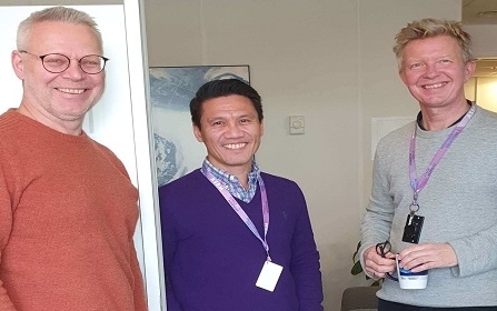
From the left: Christer Varan, Dave Duc Duong and Birger Johansen
Back to all News

Prominent visitor

Minister of Trade and Industry visits Space Norway in Dulles, USA

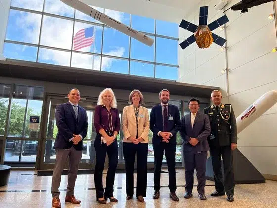
Minister Jan Christian Vestre visiting Northrop Grumman. Here with Norway's Ambassador to the USA, Anniken Krutnes, defense attaché Odd-Harald Hagen, Oddveig Tretterud from Space Norway and two representatives from Northrop Grumman. Foto: NFD

Minister of Trand and Industry Jan Christian Vestre visited the US in September 2022 . The purpose of the visit was to strengthen the historically deep industrial relations between the two countries. The agenda was further and more targeted cooperation within green tech and opportunities for Norwegian businesses.

The Minister visited Northrop Grumman in Dulles, Virginia on 8th september together with Ambassador Anniken Krutnes. They received an orientation on the building of Space Norway’s Arctic satellites. Space Norway entered an agreement with Northrop Grumman in 2019 on the building of two large satellites with military and civillian broadband communication in the Arctic. The satellites will be launched by SpaceX in mid 2024.

Back to all News

Press release

Space Norway builds radar satellite system for real-time maritime surveillance

Pressemelding: Space Norway bygger satelittsystem for sanntidsovervåking av norske havområder

On the 25th of August 2022 Space Norway AS signed contracts with vendors and will immediately start building a radar satellite system optimized for maritime surveillance in Norwegian areas of interest.

The payloads will be developed and built by Norwegian suppliers, while the satellite bus and the radar antenna will be built in the UK. The first satellite will be launched early 2025. In the following years, the plan is to launch a number of radar satellites to establish a constellation.

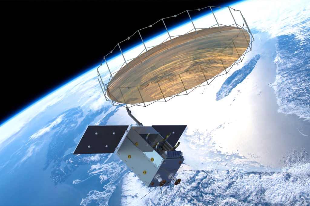
The satellite system named MicroSAR is unique in the way it can detect relatively small vessels in a very large area simultaneously. As of today we don’t know about any radar satellite systems with the same mix of capabilities.

Norway’s sea areas are seven times larger than the Norwegian land area. The Arctic and the High North is Norway’s most important strategic area of interest. This puts strong requirements on situational awareness in these areas. AIS (Automatic Identification System) has for many years been used for maritime surveillance. The challenge is that AIS is a system that requires the vessels themselves to send the required and correct AIS Information. Hence, AIS is a system based on cooperation. Today we estimate that 5 % of the vessels either does not send out AIS Information or are transmitting false information. Satellites with a radar, such as MicroSAR, will be able to detect these vessels independent of the use of AIS. MicroSAR satellites will bring an AIS Receiver to correlate radar detections with AIS Information.

The MicroSAR System is optimized for covering Norwegian needs. However, it will also offer and deliver maritime surveillance services in a global market in the same way as other radar satellites in space today, including surveillance of ship traffic, combating illegal fishing, search and rescue and oil spill detection.

Space Norway works closely with the Norwegian Armed Forces who will be the main customer and buy services and products from MicroSAR when in operation.

Space Norway also work in close cooperation with Kongsberg Satellite Services (KSAT). KSAT establishes, operates, and owns the MicroSAR Ground System, utilizing their existing global network. On behalf of Space Norway, they will provide services related to satellite operations and downlink of MicroSAR data. KSAT will also be responsible for marketing and sales of MicroSAR services and products as part of their portfolio, both in a national and an international market.

The Satellite System will be owned and controlled by Space Norway. This gives Norway an important strategic independent capability under national control to cover their needs for maritime surveillance.

Space Norway has signed contracts with the following vendors to build the first MicroSAR Satellite:

Surrey Satellite Technology Ltd (SSTL) is a UK company with long experience in building satellites. SSTL will deliver the satellite platform and be responsible for integration of the payloads on board. SSTL will also be responsible for building the radar antenna through their sub-contractor Oxford Space Systems (OSS).


The payloads will be developed and produced by the Norwegian companies WideNorth, Eidsvoll Electronics (EIDEL), Kongsberg Seatex and Norwegian Defence research Establishment (FFI). Hence, the project will also contribute significantly to business development of Norwegian companies.


Space Norway’s current plans are to launch the first satellite on a SpaceX Falcon 9 as a Rideshare. When establishing a constellation, the satellites will be launched on dedicated launchers. The establishment of Andøya Spaceport may result in future MicroSAR satellites being launched from Norway.


The MicroSAR satellites will follow polar orbits in various orbital planes at an altitude of about 600 km and will weigh about 300 kg.

Contact person:

Dag H Stølan
CSO and Director Infrastructure
Phone: +47 400 29 601
E-mail: dag-hugo.stolan@spacenorway.no

Back to all News

ASBM

Preparing to launch

A group of engineers and operators from Space Norway are currently visiting the British satellite operator Avanti in Goonhilly in Cornwall, to attend satellite operations courses. The team is strengthening their competence in satellite control and operations as a preparation for the upcoming launch of the ASBM (ASBM, Arctic Satellite Broadband Mission) satellites in 2024.

Satellite communications is understandably associated with strict security requirements and require highly dependable ground systems. The satellite operations control centre monitors the satellites 24/7. Telemetry is downloaded from the satellites and processed to ensure that all systems are operating per specification. The satellite operators work continuously in conjunction with the customers to qualify the mission requirements. The uniqueness of ASBM due to its highly elliptical choice of orbit as well as the close collaboration with its international partners Inmarsat, the Norwegian Armed Forces and the US Space Command, places significance on the development of a solid organization for satellite operations.

The Norwegian engineers are trained for a duration of two months at the British operator Avanti. Avanti was chosen for this assignment because it utilizes the same satellite operations software as Space Norway has implemented for ASBM. By participating in this training program, Space Norway ensures that its operations team holds solid competence in satellite operations prior to launching the satellites in the summer of 2024. Birger Johansen is leading the engineers from Space Norway and KSAT, and he believes they have benefited greatly from attending this training program in Goonhilly. – Our personnel collaborate very well with the satellite operators from Avanti. We have met persons with Avanti who hold a similar mindset as what we are used to from our organizations. There is a flat hierarchical structure in the company, and they share the same approach to problem-solving. The cultural similarities enable the training to be particularly efficient in readying our team for operating the satellites after launch, and contributes to significantly reducing the operational risk, states a satisfied Johansen.

The two Norwegian HEO-satellites shall be operational within one and a half year. They represent the first satellites from Western space industry to circulate the Earth in high-elliptical orbits across the two poles.

The ground stations have already been built in Tromsø and at Bardufoss and are ready to receive and process the information coming from the two satellites. Space Norway and KSAT are collaborating closely to prepare a round-the-clock, 24/7 organization for operating the ground stations once the satellites are operational in orbit.

Back to all News

ASBM ground stations

An important test

Viktig test av bakkestasjoner i ASBM-programmet

The HEOSAT-project has reached a key milestone and began end-to-end testing of the ground segment (for the satellite system) during the second half of June.

In the summer of 2024 two large satellites will be launched into a highly-elliptical orbit going across the north pole. ASBM (Arctic Satellite Broadband Mission) is Space Norway’s major initiative to pioneer providing broadband communication to the Arctic region.

During the construction of the two satellites there is a major test program implemented to ensure that all the equipment onboard is built to sustain the extreme conditions offered in a space environment and experienced during a launch. The testing involves exposing the individual satellite components to temperatures, radiation levels and vibration levels equivalent of those experienced during launch and in space.

During the construction of the two satellites there is a major test program implemented to ensure that all the equipment onboard is built to sustain the extreme conditions offered in a space environment and experienced during a launch. The testing involves exposing the individual satellite components to temperatures, radiation levels and vibration levels equivalent of those experienced during launch and in space.

The purpose of the ongoing end-to-end testing of the ground segment is to secure that the ground stations are properly connected with the customers such that all communication and exchange of data, for example ephemeris, telemetry and commands, are transferred according to plan.

The two-week long test campaign involves teams of personnel from Space Norway, the satellite provider Northrop Grumman and the ground segment provider KSAT. The customers are also an active part of the test campaign, and representatives of the Norwegian and US Armed Forces as well as Inmarsat are standby to confirm data reception at their respective ends, as well as ready to report any possible deviations from specification. In this respect, the end-to-end test campaign serves as a first full-scale test of the supply chain from the satellite operations control center to the customers.

Back to all News

ASBM

Practice makes perfect

Maintaining a stable operation as well as security are the most important features for most IT systems, and nowhere is this as important as it is in space. If a problem occurs, obviously there is no one to send. Consequently, all software and all physical parts of a satellite are thoroughly tested and retested before launch.

As a part of the delivery from satellite builder Northrop Grumman, a test environment is established on the ground where a simulator is a critical component. This satellite simulator is a digital copy of the ASBM satellites, and it is used for testing the ground stations before the actual satellites are launched into their highly elliptical orbit. The simulator is used to train the satellite engineers and operators for a range of different scenarios and all these practices are constantly evaluated.

The satellite simulator and the test environment have been through an acceptance test in Norway and is a part of the satellite operations center. The simulator enables efficient and secure testing and evaluation of every single procedure within each sub system on each satellite, such as propulsion, power, temperature management and handeling of payloads, data and TT&C (Telemetry, tracking and command).

The ASBM programme sent all its engineers and satellite operators to the British satellite operator Avanti for several months during 2022. Now, the staff spends more time in the simulator to be as prepared as possible when the satellites are sent into orbit over the poles. Once the programme enters the operational phase, the simulator will be used to test planned maneuvers before transmitting them to the satellites and for the operators to practice different scenarios.


Date June 8th 2022

Back to all News

Press release

EPS-R payload delivered and begins integration into the ASBM host vehicle

EL SEGUNDO, Calif. — Space Systems Command (SSC) delivered the first of two Enhanced Polar Systems-Recapitalization (EPS-R) payloads to begin integration on Space Norway’s Arctic Satellite Broadband Mission host space vehicles. The second payload is expected to be delivered for integration onto the second host space vehicle by the end of July 2022. SSC’s joint partnership with Norway is allowing the hosted payload to deliver capabilities three years ahead of schedule with potential savings of up to $900 million. A successful integration and testing process will highlight the effectiveness of the U.S. Space Force, Norway’s Ministry of Defense, and Space Norway’s strategic partnership.


Read the rest of the press release here.


Satellite operators are venturing into the Arctic to improve connectivity as the changing atmospheric and geopolitical climate drives demand for more bandwidth in one of Earth’s last remaining frontiers.

Satellite operators are venturing into the Arctic to improve connectivity as the changing atmospheric and geopolitical climate drives demand for more bandwidth in one of Earth’s last remaining frontiers.

This is a Space News article written by Jason Rainbow, May 13th 2022.

Fledgling and established operators alike see a growing market for capacity in areas best served by satellites in non-geostationary orbit (NGSO).

OneWeb and SpaceX’s Starlink, the world’s largest broadband megaconstellations in low Earth orbit (LEO), already have polar-orbiting satellites in their expanding fleets.

SES is looking at using inclined planes to cover the Arctic with O3b mPower, its next-generation medium Earth orbit network that aims to start deploying satellites this year.

The Arctic Satellite Broadband Mission (ASBM) — a joint venture between British satellite operator Inmarsat, the Norwegian Ministry of Defense and the U.S. Air Force — plans to deploy two satellites in highly elliptical orbits on a SpaceX Falcon 9 in 2023 for polar coverage.

Russian Satellite Communications Co. (RSCC) has outlined plans to add four satellites in highly elliptical orbits to its fleet in the following years to extend coverage deep into the Arctic Circle.

Read the complete article.

Back to all News

New technology from IDEAS and Space Norway

Keeps EU satellites safe

In a few years, the EU launches its next generation Galileo navigation satellites, the ones that give us positioning data, for gadgets such as mobile phones and watches. Together, Space Norway and IDEAS facilitate radiation data that will help the EU in planning the Galileo launch.

After detachment from the space rocket, it will take the Galileo satellites several months to reach their designated orbit, and during this period, they are exposed to severe radiation. The phase of finding its correct orbital path is called orbit raising, and for those who launch the satellites it is important to protect them as much as possible during this period. Space Norway is building two large satellites which will move in a highly elliptical orbit (HEO) in order to provide mobile broadband communication to the Arctic. For each orbit made, the satellites pass through the same altitudes as the Galileo satellites pass through during their orbit raising. With data from Space Norway’s satellites, the EU will have more accurate information about this radiation, and thus be able to better protect their future navigation satellites.

Space Norway and IDEAS cooperate in including a radiation monitor on one of the HEO satellites, and together they have made an agreement with the EU Commission on delivery of radiation data. With IDEAS’ monitor on board Space Norway’s satellite, Norwegian companies contribute to both national and European space targets and efforts. IDEAS is a Norwegian high-tech company with special competence within radiation, and with the support of the Norwegian Space Agency they have built a radiation monitor for mapping space radiation.

The monitor will deliver valuable radiation information from the unusual highly elliptical orbit, and from the Norwegian point of view, it is a considerable contribution to future space projects in the EU – especially to the EU navigation program. Based on traditionally important research within space weather and solar radiation, Norway demonstrates an important contribution to the EU space ambitions.

This cooperation is in line with the ambition of the new Norwegian space strategy of establishing robust space infrastructure supporting national security needs.